More new fires in California. . .

Talk about anything under the sun! Just remember to be respectful of others.

Re: More new fires in California. . .

Postby Cudedog » Wed Sep 08, 2021 11:24 am

Colliemom wrote:Sorry Anne, that was supposed to have read “Ida” and not “Idaho”. Dar spell correct changed my word and I didn’t catch it! I’m sure you have heard all about that storm and the mess it left behind.


Thanks, Sue. Yes, Ida was certainly a bad one. Like Martha, I truly feel sorry for all of the people in her area that are still without electricity, and so are also without a/c in the hot and steamy conditions there. Although fires here are bad (and are continuing, and will continue until we have a wetting rain) I think I would take fires and earthquakes over hurricanes and tornadoes. Truly, it is always something. . .

___________________

UPDATE 9-8-21 @ 8:25 a.m. (Wednesday)

__________________

All major fires previously listed continue to burn, although fire spread has moderated - somewhat - over the last several days, mostly due to calming winds (high wind being the primary driver of wildfire here).

Looks like that may change starting tomorrow (Thursday). A low pressure system is predicted to enter northern California with increasing winds; gusts up to 40 mph in areas of the Dixie Fire. Many areas of the Dixie fire are predicted to possibly receive a bit of rain (20% to 30% chance in many areas of these ongoing fires).

Whether or not rain actually falls remains to be seen.

Having lived in this area for more than 40 years, I know that a '30% chance of rain' is not a very good chance, more of the 'slim to none' variety, especially thinking of a "wetting rain". But one can hope! A "Wetting Rain" ("A widespread rain that over an extended period of time significantly reduces fire danger. One-tenth of an inch may be sufficient to reduce fire danger in grass fuel models. One half inch may be necessary for timber fuels under closed canopies." https://www.nwcg.gov/term/glossary/wetting-rain)

Unfortunately, along with this low pressure system will be the return of high winds, along with likely dry lightning strikes throughout the northern part of the state.

In 2020 (only last year!) the largest fire in California state history - the August Complex Fire, burning over a million acres - was ignited by lightning a little more than a year ago (August 16 - 17, 2020).

If anything, with "extreme drought" over much of northern California, conditions conducive to fire starts are worse now than they were last year.

Looking at the maps, it appears that Lassen Volcanic National Park has been about 75% burned over by the Dixie Fire (with fire still currently burning inside and outside the boundaries of the park).

The Antelope fire has been burning on the slopes of the Medicine Lake Volcano (by many estimates the largest volcano in the Cascade Range, with a "footprint" covering about eight-hundred square miles), and this morning Antelope appears to be on point of entering Lava Beds National Monument (home of about 600+ lava tube caves - one of the greatest concentration of such caves in the world). About 70% of the monument was burned over in August of 2020 by the Caldwell Fire, it looks like Antelope might now be trying to finish the job.

Further, it appears that the Monument Fire and the Haypress Fire may be on point of burning together to create still another mega fire in California’s mountainous coast range. Only about 5 miles separates the two fires from each other at the present time.

Additionally, many communities – both large and small – remain threatened by these fires.

FIRE UPDATES ARE BELOW THE PHOTOS

Photos are of the Dixie Fire - courtesy InciWeb
Image

Image

Image


Dixie Fire - now at 922,192 acres (an increase of 8,340 acres over my previous update), 59% contained. Estimate of full containment October 30.

For further information on the Dixie:
https://inciweb.nwcg.gov/incident/7690/

Caldor Fire - now at 217,569 acres (an increase of 2,169 acres over my last update) 50% contained. Full containment predicted for September 27 (extended from September 7 on my previous update).

For further information on the Caldor Fire:
https://inciweb.nwcg.gov/incident/7801/

Monument Fire 189,366 acres (an increase of 29,218 acres over my last update) 41% contained. Estimate of full containment is still November 1.

For further information on the Monument Fire:
https://inciweb.nwcg.gov/incident/7750/

Antelope Fire – 73,558 acres, (an increase of 2,053 acres over my last update) 83% contained. Estimate of full containment September 30.

For more information on the Antelope Fire:
https://inciweb.nwcg.gov/incident/7764/

River Complex Fire – 135,689 acres (an increase of 14,416 acres over previous update) 19% contained (containment has been reduced from previous update due to fire spread). Estimate of full containment: October 1.

For further information on the River Complex Fire:
https://inciweb.nwcg.gov/incident/7760/

McCash Fire – 59,489 acres (an increase of 4,664 acres since my last update). 15% contained. Estimate of full containment October 31.

For further information on the McCash Fire:
https://inciweb.nwcg.gov/incident/7757/

McFarland Fire – 122,653 acres (fire size remains unchanged - acreage has not been updated since September 2) 98% contained. Estimate of full containment September 9.

For further information on the McFarland Fire:
https://inciweb.nwcg.gov/incident/7746/

Thanks to all for following this thread.

I remain very concerned at the possibility of lightning strikes igniting new fires tomorrow (Thursday) into Friday, and the possibility/likelihood of wind gusts, (both lightning and wind gusts initiated by the approaching low pressure area), causing further fire spread of the many fires still currently burning within the state.

Karen, I read yesterday of a new fire start in the Rogue River area of Oregon, have not seen any further details on this fire; so hoping it isn’t another bad one. If you have any details to share from your perspective, I am sure everyone would be happy to hear them. My sincere condolences on the loss of your home one year ago.

I will update this thread more often as new information becomes available.

Thank you.

Anne
The Stone Wind
Hand Made Hammered Copper & Natural Stone Jewelry
https://www.etsy.com/shop/thestonewind/
User avatar
Cudedog
 
Posts: 2937
Joined: Fri Jan 04, 2013 1:39 pm

Re: More new fires in California. . .

Postby Cudedog » Thu Sep 09, 2021 11:15 am

___________________

UPDATE 9-9-21 @ 8:25 a.m. (Thursday)

__________________

Brief update this morning (for more in-depth information on each of the major fires burning in northern California, the links in the previous post are updated daily by Inciweb to reflect the most current information).

DIXIE FIRE

Last evening at 7:00 p.m, the town of Old Station (a popular spot for campers and RV'ers, with many campgrounds and resorts in the area) was put on Mandatory Evacuation order due to the approach of the Dixie Fire, currently at 927,320 acres (up from 922,192 acres yesterday - an increase of 5,128 acres). Old Station is north and a bit west of Lassen Volcanic National Park; Dixie is approaching from the south, after burning through much of Lassen.

From Inciweb: "The National Weather Service in Reno has issued a Fire Weather Watch for the Dixie Fire area for late tonight through Friday (9-9-21 at 11:00 PM through 9-10-21). Thunderstorms, strong outflow winds, and light rains are likely tonight, then gusty winds and low humidity are expected through the day tomorrow. . .

Last night at 7:00 PM, Old Station was put under a Mandatory Evacuation Order. The wind continued into the evening, increasing fire activity. The northern portion continued to have active runs in the brush and ground fuels with occasional group torching. Interior islands contunued to burn and smolder through the night. Heavy fuels continue to consume throughout the fire perimeter."


For anyone interested, a virtual Community Meeting regarding Dixie will be held tomorrow, September 10, by the United States Forest Service.

This meeting will be live, on either the Lassen or Plumas National Forest's Facebook pages, or watch on Zoom using the conference line ID# 872 3351 2060, with a call-in number of 720-707-2699.

Dixie is still very actively burning, next Monday it will be two months since it began on July 13.

"The Dixie Fire started on July 13th. The fire is burning on the Plumas National Forest, Lassen National Forest, Lassen Volcanic National Park, and in five counties: Butte, Lassen, Plumas, Shasta and Tehama. The Fly Fire started on July 22nd and was managed under the Dixie Fire East Zone command as the two fires eventually merged into one. The drought, combined with hot weather, strong winds, and exceptionally dry vegetation, has resulted in very active fire behavior."

The distance between the south eastern arm of Dixe and the north west arm of the fire is about 90 miles, 'as the crow flies'.

Multiple videos of Dixie have been posted to Inciweb:
https://inciweb.nwcg.gov/incident/videos/7690/

Inciweb Dixie page:
https://inciweb.nwcg.gov/incident/7690/

Anne
Photo courtesy Inciweb:
Image
The Stone Wind
Hand Made Hammered Copper & Natural Stone Jewelry
https://www.etsy.com/shop/thestonewind/
User avatar
Cudedog
 
Posts: 2937
Joined: Fri Jan 04, 2013 1:39 pm

Re: More new fires in California. . .

Postby Cudedog » Tue Sep 14, 2021 1:01 pm

___________________

UPDATE 9-16-21 @ 5:03 Pacific Time. (Thursday)

__________________

The National Weather Service is predicting up to a 30% to 50% chance of rain, possibly heavy at times, over various fire areas.

This is extremely welcome - and somewhat surprising news. Welcome, because any rain - at all - will go a long way to help subdue these fires. Surprising, because this is a bit early for rain here (The Camp Fire, which burned the town of Paradise to the ground, ignited in the early part of November). The rains were late that year - 2018 - and there had not been any significant rain in the area since late April/early May.

Generally, our "rainy season" starts mid to late October.

If we do get rain (at the moment, there is only a "chance") it might not dampen all fire areas. California has a very mixed topography (and this sometimes affects where it rains, and how much). It is not unusual for it to rain steadily in one place, with no rain at all somewhere as close as 40 or 50 miles away.

However, we can but hope.

Now on to fire updates.

___________________________

The KNP Complex Fire is currently burning, threatening both Sequoia and Kings Canyon National Parks.

Current weather conditions (from InciWeb):

"A dry onshore flow will maintain dry conditions over the fire through the week. Afternoon highs will remain a few degrees above seasonal average over the fire through the middle of the week. A cooling trend will take place beginning on Thursday and continue through next weekend. Good ventilation will favor fire growth. Westerly afternoon and evening winds of 15 to 25 mph with gusts to 40 mph will continue to surface over the wind prone mountain and desert areas through the middle of this week."

KNP Complex Fire 8,940 acres (increased from 5,861 acres from previous update). No estimates of containment given. Cause: Lightning.

For further information on the KNP Complex Fire, please click the link below:

https://inciweb.nwcg.gov/incident/7838/

Information on the other major fires burning in northern California are below the photos. Photos courtesy of InciWeb.

Image

Image

Dixie Fire - now at 960,470 acres (no update in acres burned over previous update), 86% contained. Estimate of full containment September 30.

For further information on the Dixie:
https://inciweb.nwcg.gov/incident/7690/

Caldor Fire - now at 219,267 acres (no update in burned acres over last update) now 71% contained. Full containment predicted for September 27.

For further information on the Caldor Fire:
https://inciweb.nwcg.gov/incident/7801/

Monument Fire 213,319 acres (an increase of 2,625 acres over last update) 43% contained. Estimate of full containment is still November 1.

For further information on the Monument Fire:
https://inciweb.nwcg.gov/incident/7750/

Antelope Fire – 145,204 acres, (a minimal increase of 157 acres over last update) 73% contained. Estimate of full containment September 30.

For more information on the Antelope Fire:
https://inciweb.nwcg.gov/incident/7764/

River Complex Fire – 186,447 acres (an increase of 2,638 acres over previous update) Remains at 40% contained. Estimate of full containment: November 1.

For further information on the River Complex Fire:
https://inciweb.nwcg.gov/incident/7760/

McCash Fire – 80,611 acres (an increase of 3,383 acres since my last update). 10% contained. Estimate of full October 31.

For further information on the McCash Fire:
https://inciweb.nwcg.gov/incident/7757/

Thanks to all for following this thread.

Thank you.

Anne
Last edited by Cudedog on Thu Sep 16, 2021 7:40 pm, edited 1 time in total.
The Stone Wind
Hand Made Hammered Copper & Natural Stone Jewelry
https://www.etsy.com/shop/thestonewind/
User avatar
Cudedog
 
Posts: 2937
Joined: Fri Jan 04, 2013 1:39 pm

Re: More new fires in California. . .

Postby Cudedog » Tue Sep 14, 2021 6:00 pm

___________________

UPDATE 9-14-21 @ 3:50 p.m. (Tuesday - second update of the day)

__________________

A new fire potentially major fire, the KNP Complex Fire, is now burning in Sequoia and Kings Canyon National parks. Mandatory evacuations are in progress. This fire was ignited September 9 by the widespread lightning storms here in California of a few days past.

Currently burning at 5,861 acres with zero containment.

There are unverified reports that the ancient (and famous), old-growth redwood trees in the area of this fire may be under threat.

This from Inciweb:

"SEQUOIA AND KINGS CANYON NATIONAL PARKS, Calif. September 14, 2021 – The KNP Complex, ignited by lightning on the night of September 9, continues to grow in Sequoia National Park. The complex is comprised of the Paradise Fire and the Colony Fire. Last night, the Paradise Fire made a downhill run, and crossed the middle fork of the Kaweah River and the Generals Highway. As a result of this, the parks are evacuating employees from the Ash Mountain Headquarters Complex and nearby housing areas.

In the coming days, the current and the incoming Type 1 Incident Management Team will operate out of the Three Rivers Memorial Building. Per Tulare County Sheriff, part of the community of Three Rivers remains under evacuation warning. This area includes all points along both sides of Highway 198 between the intersection with North Fork Drive and the entrance to Sequoia National Park. North Fork and South Fork Drives are not included in the evacuation warning. The evacuation warning is not an order. It means that residents should prepare for the possibility of evacuation, so that they will be ready to mobilize and leave should the evacuation warning escalate to an evacuation order. Mineral King remains under evacuation order."


For further information on the KNP Complex Fire, please click the link below:

https://inciweb.nwcg.gov/incident/7838/

Anne
The Stone Wind
Hand Made Hammered Copper & Natural Stone Jewelry
https://www.etsy.com/shop/thestonewind/
User avatar
Cudedog
 
Posts: 2937
Joined: Fri Jan 04, 2013 1:39 pm

Re: More new fires in California. . .

Postby Cudedog » Thu Sep 16, 2021 8:45 pm

_________

"Mini"-update :? , 9/16/21 @ 7:00 p.m. Pacific Time (Thursday).

_________

Well, I spent well over an hour putting together a regular fire update. Been a long day, I'm a bit tired - accidentally closed the window, the post was toast. 8-)

It was that kind of day.

I'll try for an over-all update perhaps tomorrow; hopefully the possibility of rain (currently predicted at 20 - 50%) will be more likely by then.

The fire of most concern at the moment is the KNP Complex fire of Sequoia National Park, acreage up from just over five-thousand acres at the previous update to now at nearly ten thousand acres.

Here is the link for information for that fire:

https://inciweb.nwcg.gov/incident/7838/

Current weather concerns for the KNP Fire Complex (courtesy of InciWeb) - (not good - no mention of any possible rain):

"A dry onshore flow will maintain dry conditions over the fire through the week. Afternoon highs will remain a few degrees above seasonal average over the fire through the middle of the week. A cooling trend will take place beginning on Thursday and continue through next weekend. Good ventilation will favor fire growth. Westerly afternoon and evening winds of 15 to 25 mph with gusts to 40 mph will continue to surface over the wind prone mountain and desert areas through the middle of this week."

Further KNP Fire Complex information from Yuba Net:

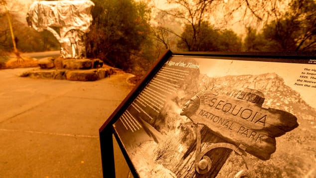
"Crews are preparing the Giant Forest before the fire reaches that area, by removing fuel and applying structure wrap on some of the iconic monarch sequoias that characterize the most famous area of Sequoia National Park. The fire continues to grow in all directions. In recent days, crews continue structure protection around NPS headquarters and housing areas at Ash Mountain. Air operations is providing support to crews on the ground as well as structure protection for cabins in the Mineral King area. Cal-Fire and Tulare County is providing structure protection efforts in the Three Rivers Community outside the park, including creating fire breaks with dozers."

I don't know if structure wrap has ever been tried on trees before, but I do know that it has been tried on structures, and has worked well at saving many of them. However, if a crown fire gets going in there (the fire jumping from the top - the crown - of one tree to the next, maybe in all directions. . . it won't be good.

Please keep these ancient and majestic trees in your prayers.

*****

All of the other major fires have moderated substantially, neither Dixie or Caldor has added any new advancements since my last update (although both fires continue to burn in isolated, difficult-to-access, areas inside the fire line).

With "a chance of rain" for the weekend here in northern California (very early here for rain - rain usually arrives mid-to-late October) but we will take what we can get.

The topography of California is more diverse than many people realize; this topography affects where it might rain (or not), and how much. It is not unusual for one place to receive steady rain, another place 40 or 50 miles away to get no rain at all.

So who knows if it will rain in the fire areas or not.

But we will keep our fingers crossed.

The information under the links to all fires in my previous update should still be current - InciWeb updates the linked-to information on a daily basis.

My apologies, and thanks for reading this thread.

Anne
Photos (below) of KNP Complex fire, courtesy of InciWeb

Image

Image
The Stone Wind
Hand Made Hammered Copper & Natural Stone Jewelry
https://www.etsy.com/shop/thestonewind/
User avatar
Cudedog
 
Posts: 2937
Joined: Fri Jan 04, 2013 1:39 pm

Re: More new fires in California. . .

Postby Cudedog » Sat Sep 18, 2021 5:05 pm

_________

"Mini"-update :? , 9/18/21 @ 3:03 p.m. Pacific Time (Saturday).

_________

I'm working on another update that I will post as soon as I finish gathering information.

Here is the latest:

From the Los Angeles Times:

"Wildfire reaches Giant Forest; fate of giant sequoias unknown"

https://www.latimes.com/california/story/2021-09-18/wildfire-reaches-giant-forest-fate-of-giant-sequoias-unknown

From CNN:

"Officials wrapped the world's largest tree in protective foil to guard it against California wildfires"

https://www.cnn.com/travel/article/sequ ... index.html

Image
The Stone Wind
Hand Made Hammered Copper & Natural Stone Jewelry
https://www.etsy.com/shop/thestonewind/
User avatar
Cudedog
 
Posts: 2937
Joined: Fri Jan 04, 2013 1:39 pm

Re: More new fires in California. . .

Postby Cudedog » Sat Sep 18, 2021 5:59 pm

_________

Main Update, 9/18/21 @ 3:03 p.m. Pacific Time (Saturday). Second update of the day.

_________

Before I begin, thought I would post the "interesting" weather forecast for my area, from weather.gov, the U. S. Government National Weather Service.

For tonight (Saturday) - 50% chance of rain ("with less than 1/10 of an inch possible"), tomorrow (Sunday) morning 20% chance of rain, Sunday afternoon, sunny.

Starting Sunday evening (here's the kicker), a "Fire Weather Watch" will THEN be in effect.

"A Fire Weather Watch means that critical fire weather conditions
are forecast to occur. Listen for later forecasts and possible
Red Flag Warnings."

* IMPACTS...any fires that develop will likely spread rapidly.
Outdoor burning is not recommended.


https://forecast.weather.gov/showsigwx.php?warnzone=CAZ016&warncounty=CAC101&firewxzone=CAZ216&local_place1=Yuba%20City%20CA&product1=Fire+Weather+Watch&lat=39.1409&lon=-121.6199#.YUZol31lBIA

This is an indication of how very bad conditions are here in California - that is, immediately after a predicted rain, fire conditions will actually be worsening.

One might think that the opposite should be true (rain, even light rain, if it comes, might be expected to help subdue a fire).

Right now, in California. . . not so much. It is THAT dry here.

_________________________________

Now for the regular update:

_________________________________

KNP Complex Fire (Sequoia National Forest), now at 17,857 acres (increased 8,917 acres over previous update). Started by lightning. Zero containment. No estimate regarding future containment.

(Updates continue below these photos showing the Sequoias being wrapped against the approaching KNP Complex Fire - photos courtesy InciWeb)

Image

Image

Current weather over the KNP Complex Fire (from InciWeb):

"Despite very smoky conditions over the KNP Complex, conditions remained mild and very dry today with temps in the 70s and 80s with humidity dropping to near 10%. Winds have been mainly light to moderate and out of the south. Little to no recovery is expected tonight. A Fire Weather Watch has been issued for Saturday afternoon into Sunday for gusty winds and low humidity."

The grove of ancient Sequoias remains threatened, including the world's largest living tree.

For further information on the KNP Complex Fire, please click here:

https://inciweb.nwcg.gov/incident/7838/

Dixie Fire - now at 960,641 acres (increase of 171 acres over last update), 88% contained. Estimate of full containment September 30.

For further information on the Dixie:
https://inciweb.nwcg.gov/incident/7690/

Caldor Fire - now at 218,876 acres (acres burned adjusted downward due to better mapping) now 71% contained. Full containment predicted for September 27.

For further information on the Caldor Fire:
https://inciweb.nwcg.gov/incident/7801/

Monument Fire 218,457 acres (an increase of 5,138 acres over last update) 43% contained. Estimate of full containment is still November 1.

For further information on the Monument Fire:
https://inciweb.nwcg.gov/incident/7750/

Antelope Fire – 145,204 acres, (a minimal increase of 39 acres over last update) 73% contained. Estimate of full containment September 30.

For more information on the Antelope Fire:
https://inciweb.nwcg.gov/incident/7764/

River Complex Fire – 190,884 acres (an increase of 4,437 acres over previous update) Remains at 45% contained. Estimate of full containment: November 1.

For further information on the River Complex Fire:
https://inciweb.nwcg.gov/incident/7760/

McCash Fire – 80,611 acres (an increase of 3,860 acres since my last update). 26% contained. Estimate of full October 31.

For further information on the McCash Fire:
https://inciweb.nwcg.gov/incident/7757/

Thanks to all for following this thread.

Any and all comments are appreciated.

Thank you.

Anne
The Stone Wind
Hand Made Hammered Copper & Natural Stone Jewelry
https://www.etsy.com/shop/thestonewind/
User avatar
Cudedog
 
Posts: 2937
Joined: Fri Jan 04, 2013 1:39 pm

Re: More new fires in California. . .

Postby Colliemom » Sun Sep 19, 2021 8:34 am

Thanks for posting all that Anne. Keeping my fingers crossed that the sequoias survive. I know you will keep us updated on it.

As to the rainfall, we have the same thing here in Michigan. It can be pouring down rain amile up the road and absolutely nothing when I am. Heck, it can even rain across my road here and nothing on my side.

One summer when I was working at the park, we had a downpour on the north end and bone dry on the south. Nature works in strange ways.
Sue and the Furry Crew
Colliemom
 
Posts: 5218
Joined: Wed Apr 07, 2010 6:49 pm
Location: Northern Michigan

Previous

Return to General Talk

Who is online

Users browsing this forum: No registered users and 8 guests